





Underground Cable Locator for Roadworks and Civil Contractors Malaysia

Underground Cable Locator for Roadworks and Civil Contractors Malaysia
Why Do Roadworks and Civil Contractors Need an Underground Cable Locator?
Before an excavator, backhoe, trencher, auger or drilling machine enters the ground, one question matters:
“WHAT UNDERGROUND UTILITIES ARE INSIDE THIS WORK AREA?”
Roadworks and civil construction can encounter:
underground power cables,
street-lighting cables,
communication routes,
metallic water pipelines,
other conductive utilities
and multiple services running inside the same corridor.
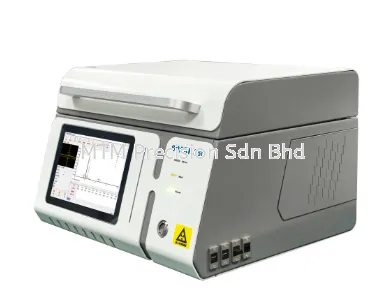
The FUZRR ES7080 Underground Utilities Locator is designed for path detection, survey and depth measurement of underground cables and metallic pipelines. Its functions include passive searching, active locating, multiple positioning modes, Current Direction, current measurement and cable identification.
For civil contractors, the most important positioning is:
DON'T JUST SCAN WHERE THE EXCAVATOR WILL DIG.
ESTABLISH THE UNDERGROUND UTILITY ROUTES THROUGH THE COMPLETE WORK ZONE.
1. Underground Utility Damage Is a Route Problem, Not Just a Point Problem
Suppose excavation will follow:
PROPOSED TRENCH
│
│
│
│
│
A cable may cross it:
Cable ━━━━━━━━━━━━━━━━━━━
             │
             │ Trench
             │
But another cable could run almost parallel:
Cable ━━━━━━━━━━━━━━━━━━━━━

Trench ━━━━━━━━━━━━━━━━━━━━━
Or turn into the work area:
Cable ━━━━━━━━┓
              ┃
              ┃
              ┃
Therefore, checking only one point is not enough.
The contractor needs to understand:
ROUTE + DIRECTION + CROSSINGS + DEPTH + UNCERTAINTY
before excavation.
2. Application 1 — Underground Utility Survey Before Road Excavation
Before:
road widening,
road reconstruction,
drain installation,
culvert construction,
kerb work,
footpath construction
or:
utility trenching,
perform an underground utility search across the planned work zone.
A practical sequence is:
SEARCH
↓
MARK CANDIDATE UTILITIES
↓
TRACE EACH ROUTE
↓
VERIFY TARGETS WHERE POSSIBLE
↓
CHECK CROSSINGS
↓
MEASURE DEPTH
↓
MARK BEFORE EXCAVATION
3. Start With Existing Utility Information
Before scanning, review available:
utility drawings,
as-built drawings,
site plans,
manholes,
cable chambers,
substations,
distribution boxes
and other visible clues.
But drawings should be treated as:
SEARCH GUIDANCE
not absolute proof of the present underground position.
The ES7080 provides field locating information to complement those records.
4. What If the Contractor Has No Cable Drawing?
This is where regional searching becomes important.
If the route is completely unknown, do not immediately place the transmitter somewhere and assume a target.
Begin by searching the work area.
The ES7080 receiver supports passive power-frequency and RF regional detection.
5. Passive Search Is Valuable Before Roadworks
Passive searching requires only the receiver.
For operating cables, the ES7080 provides passive power-frequency modes including:
50Hz
60Hz
250Hz.
This can reveal candidate underground routes without connecting the transmitter.
For pre-excavation work:
PASSIVE SEARCH = FIRST LOOK AT THE SITE
6. But Passive Power Does Not Automatically Mean “Power Cable”
This is a critical interpretation rule.
A metallic pipeline can carry induced current from nearby electrical infrastructure.
Therefore:
POWER-FREQUENCY RESPONSE ≠ PROOF OF UTILITY TYPE
The receiver tells you that a detectable electromagnetic response exists.
It does not automatically tell you:
ownership,
voltage,
service status
or:
exact utility type.
7. Use Passive RF as Another Search Method
A line that produces little useful Power response may still produce an RF response under suitable conditions.
Therefore, an unknown-area survey can use:
POWER SEARCH
↓
RF SEARCH
↓
MARK REPEATABLE RESPONSES
↓
ACTIVE TRACE WHERE POSSIBLE
This is stronger than performing one quick Power-mode sweep and declaring the area clear.
8. Search in a Grid Pattern
For a rectangular excavation zone:
┌────────────────────────────┐
│ ↑    ↑    ↑    ↑    ↑     │
│ │    │    │    │    │     │
│ ↓    ↓    ↓    ↓    ↓     │
│                            │
│ ←──────────────────────→   │
│                            │
│ ↑    ↑    ↑    ↑    ↑     │
│ │    │    │    │    │     │
│ ↓    ↓    ↓    ↓    ↓     │
└────────────────────────────┘
Search from more than one direction.
Why?
Because the objective is not:
“Find one strong cable.”
It is:
“FIND THE UTILITIES THAT MAY AFFECT THIS EXCAVATION.”
9. Search Beyond the Exact Excavation Boundary
Suppose the excavation is:
┌───────────────┐
│     WORK      │
│     AREA      │
└───────────────┘
Do not stop exactly at its edge.
A cable may turn immediately outside the excavation:
━━━━━━━━━━┓
          ┃
     ┌────┃─────────┐
     │    ┃ WORK    │
     │    ┃ AREA    │
     └────┃─────────┘
Tracing beyond the boundary helps establish route continuity.
10. Application 2 — Trace a Known Underground Cable Across a Road
If the contractor knows a cable enters the road here:
●
│
│
════════════════════ ROAD
│
│
?
the job is to establish where it exits and how it crosses.
Do not simply assume:
●
│
│
│
│
●
The cable may cross diagonally:
●
 \
  \
   \
    \
     ●
or turn beneath the road.
11. Active Locating Gives Better Target Control
Once a known target is available, the ES7080 transmitter provides:
DIRECT CONNECTION
CLAMP COUPLING
INDUCTION.
Each method has a different role.
For civil work, the most selective suitable method is generally preferable when identifying a specific known utility.
12. Direct Connection Is the Preferred Method Where Suitable
According to the ES7080 manual, Direct Connection provides maximum transmitting current and should be used where suitable.
This can produce a stronger and more selective signal on the target.
For example:
Cable A ━━━━━━━━━━━━━━━━━━━

TARGET  ━━━━━━━━━━━━━━━━━━━

Pipe C  ━━━━━━━━━━━━━━━━━━━
The objective is to place the active locating signal primarily on:
TARGET
rather than exciting the whole corridor.
Electrical connections must be made by appropriately trained and authorized personnel according to the manufacturer's and site safety procedures.
13. Clamp Coupling Is Another Active Option
Where a suitable cable is accessible but direct electrical connection is not appropriate, the transmitter clamp can couple a locating signal onto the cable.
The ES7080 transmitter clamp has an internal diameter of approximately:
φ125mm.
Clamp Coupling can be useful at suitable:
cable chambers,
accessible cable sections
or other controlled access points.
14. Induction Can Help During Exploratory Civil Surveys
If there is no exposed target point, Induction provides another option.
The transmitter can be positioned above the expected route without physical connection.
Conceptually:
       ES7080 TX
         [TX]

════════════════════ ROAD

     Buried Cable
━━━━━━━━━━━━━━━━━━━━
This can be useful before excavation.
However:
INDUCTION IS LESS SELECTIVE THAN A CONTROLLED CONNECTION.
Nearby conductive utilities may also receive the signal.
15. ES7080 Induction Has an Important Depth Limitation
The manufacturer's specification states that Induction is suitable for cables buried:
LESS THAN 2m
under the stated detection conditions.
This should not be confused with the ES7080's much larger pipeline depth-measurement specification.
In other words:
0–20m DEPTH MEASUREMENT RANGE
does not mean:
20m INDUCTION CABLE DETECTION.
16. ES7080 Induction Frequencies
Induction supports:
32.7kHz
81.9kHz
197kHz
So:
3.20kHz IS NOT AN ES7080 INDUCTION FREQUENCY.
This distinction is important for operator training.
17. Application 3 — Road Widening
Imagine an existing road:
        EXISTING ROAD
══════════════════════════
will be widened:
NEW AREA | EXISTING ROAD | NEW AREA
─────────═════════════════─────────
Utilities that were previously beside the road may now fall directly beneath:
new pavement,
drains,
kerbs
or:
foundations.
Therefore, the survey should include both:
EXISTING ROAD + PROPOSED WIDENING ZONE
18. Application 4 — Drainage and Culvert Construction
Drainage work often involves long continuous excavation.
Example:
PROPOSED DRAIN
━━━━━━━━━━━━━━━━━━━━━━━━━━
Underground utilities may:
cross once,
cross multiple times,
run parallel,
change direction
or:
enter the drain alignment.
The correct objective is therefore:
MAP EVERY DETECTABLE CROSSING ALONG THE FULL DRAIN ROUTE.
19. Application 5 — Horizontal Boring or HDD Preparation
A boring project can be particularly sensitive because the machine travels underground where the operator cannot visually see buried services.
Before boring:
LOCATE THE EXISTING UTILITIES
↓
TRACE THEIR ROUTES
↓
ESTABLISH CROSSING POINTS
↓
MEASURE DEPTH AT SUITABLE LOCATIONS
↓
MARK UNCERTAINTY
The locator is one component of the project's underground-utility verification process.
20. Application 6 — Road Saw Cutting and Core Drilling
Not every utility strike comes from deep excavation.
Ground disturbance can include:
saw cutting,
core drilling,
anchor drilling
or:
post installation.
If buried electrical infrastructure may be present, route verification should be considered before penetration.
21. Application 7 — Street-Light Cable Routes
Road projects frequently encounter underground street-lighting circuits.
A route might run:
Pole ●━━━━●━━━━●━━━━●━━━━● Pole
but repair history may have changed sections.
Under suitable locating conditions, the ES7080 can help trace the buried conductive route.
Again:
THE LOCATOR DOES NOT AUTOMATICALLY IDENTIFY OWNERSHIP.
A detected cable should not be labeled as a specific authority's cable without external verification.
22. Application 8 — Utility Corridor With Several Parallel Lines
A roadside corridor may contain:
Power Cable      ━━━━━━━━━━━━━━━

Metal Water Pipe ━━━━━━━━━━━━━━━

Other Cable      ━━━━━━━━━━━━━━━

Metal Pipeline   ━━━━━━━━━━━━━━━
This is where simple “strongest signal” locating becomes risky.
The ES7080 provides:
Wide Peak
Narrow Peak
Sound Valley.
These give the operator multiple ways to investigate the field.
23. Wide Peak for Finding and Following
Wide Peak provides higher sensitivity with a broader response.
Use it for:
FIND & FOLLOW
especially during initial route tracing.
24. Narrow Peak for Separating Nearby Utilities
When utilities run close together:
NARROW PEAK = SEPARATE & REFINE
Example:
Utility A ━━━━━━━━━━━━━━━━━

Target    ━━━━━━━━━━━━━━━━━

Utility C ━━━━━━━━━━━━━━━━━
A narrower response can help refine each route.
But target identity still needs verification.
25. Sound Valley Provides Another Position Reference
Sound Valley uses a response minimum over the target under ideal field conditions.
If:
PEAK POSITION = A
VALLEY POSITION = A
confidence is stronger.
If:
PEAK POSITION = A

VALLEY POSITION =       B
the field may be distorted.
That is a warning to investigate before marking the cable centreline.
26. Application 9 — Detect Field Distortion Before Excavation
The ES7080 provides:
SIGNAL DISTORTION MEASUREMENT MODE.
This is particularly useful around:
parallel utilities,
roadside metal structures,
reinforced concrete,
bonded pipelines
and other conductive infrastructure.
In an undistorted field, Peak and Valley should approximately coincide and the response should be symmetrical.
27. Why Field Distortion Matters to a Civil Contractor
Imagine:
ACTUAL CABLE
     ↓
━━━━━●━━━━━━━━━━━━━━━━
but the field suggests:
ACTUAL       APPARENT
   ↓             ↓
━━━●━━━━━━━━━━━━━●━━━━
If the excavation mark is placed only at the apparent maximum:
THE MARK MAY NOT REPRESENT THE TRUE CABLE CENTRELINE.
Therefore:
CHECK SIGNAL QUALITY BEFORE TRUSTING POSITION.
28. Application 10 — Avoid Jumping to an Adjacent Cable
Suppose a contractor traces:
Target ━━━━━━━━━━━━━━━━━━━
then reaches a corridor with:
Target   ━━━━━━━━━━━━━━━━━

Adjacent ━━━━━━━━━━━━━━━━━
The signal couples onto the adjacent line.
If the adjacent line becomes shallower, it may produce the stronger response.
This can cause:
WRONG-LINE TRACKING.
29. Current Direction Helps Reduce Wrong-Line Tracking
The ES7080 provides Current Direction Determination at selected frequencies specifically to help reduce adjacent-line interference and prevent tracking errors.
Supported Current Direction frequencies are:
640Hz
1.28kHz
2.56kHz
3.20kHz
This is a major advantage in congested roadside utility corridors.
30. Current Direction Must Be Calibrated on the Known Target
The practical principle is:
FIRST KNOW WHICH CABLE IS CORRECT.
Then calibrate its current direction.
The manufacturer's guidance places calibration approximately:
5–10m from the transmitter
on a known target section and outside the immediate interference area.
After that, Current Direction becomes another target-verification parameter.
31. Current Measurement Helps Too
The ES7080 receiver provides real-time pipeline current measurement from:
0–1A.
The operator can therefore compare:
signal strength,
current,
Current Direction
and:
route continuity.
This is much better than simply following whichever signal is strongest.
32. Application 11 — Measure Utility Depth Before Excavation
After the correct route is verified, ES7080 can measure depth.
The manufacturer specifies:
0–20m
as the pipeline measurement-depth range.
But this must be interpreted correctly.
It is:
AN INSTRUMENT MEASUREMENT RANGE
not:
A GUARANTEE THAT EVERY UTILITY CAN BE DETECTED AT 20m.
33. Never Measure Depth Before Confirming the Target
The correct order is:
ROUTE
↓
TARGET
↓
CENTRELINE
↓
FIELD QUALITY
↓
DEPTH
If the receiver has jumped to another utility, a perfectly stable depth reading is still useless.
34. Automatic Depth Should Be Treated Carefully for Critical Excavation
The manufacturer's manual says automatic real-time depth should be treated as reference in stricter pipeline exploration.
It provides additional manual methods:
Sound Valley 45°
Wide Peak 80%
for depth determination.
For critical crossings, verification is more important than simply reading one automatic number.
35. Use the Receiver-Raising Depth Check
A useful ES7080 verification method is:
Measure depth normally.
Then:
Raise the receiver approximately 0.5m.
Measure again.
If the displayed depth also increases by approximately:
0.5m
the reading is more credible.
36. Avoid Measuring Depth at Turns or T-Junctions
Consider:
━━━━━━━━━━┓
          ┃
          ┃
or:
━━━━━━━━━━┳━━━━━━━━━━
          ┃
These geometries can distort the electromagnetic field.
The manufacturer's guidance recommends taking important depth readings approximately:
5m away where possible
from turns and T-junctions.
37. Application 12 — Locate Metallic Pipes Before Roadworks
The ES7080 is not only a cable locator.
It is also designed for:
UNDERGROUND METALLIC PIPELINES.
This can potentially include suitable:
metal water lines,
industrial metallic pipelines
and other conductive buried services.
38. ES7080 Does Not Detect Water Itself
If ES7080 traces a metallic water pipe, it is locating the:
CONDUCTIVE METALLIC PIPE
not:
THE WATER INSIDE IT.
This distinction matters when explaining the product to civil contractors.
39. Ordinary Plastic Pipe Is Not the Same Target
Non-conductive:
PVC,
HDPE,
PE
without a suitable conductive tracer should not be presented as directly detectable in the same way as a metal pipe.
So before quoting a pipe locator, ask:
“WHAT MATERIAL IS THE PIPE?”
40. Application 13 — Utility Mapping for Future Road Maintenance
Civil contractors can also use underground locating to improve records.
For example:
| Road Chainage | Utility | Route | Depth Reference |
|---|---|---|---|
| CH 0+100 | Cable | Crossing | Site reading |
| CH 0+180 | Metallic pipe | Parallel | Site reading |
| CH 0+250 | Cable | Diagonal crossing | Site reading |
| CH 0+420 | Multiple utilities | Corridor | Verify individually |
This creates a much better future maintenance reference than:
“Cable somewhere near the road.”
41. Application 14 — Cable Identification at Chambers
Suppose route tracing reaches a chamber containing:
○ Cable 1
○ Cable 2
○ Cable 3
○ Cable 4
○ Cable 5
Route locating answers:
“The target reaches this chamber.”
But not necessarily:
“Which cable inside the chamber is it?”
The ES7080 includes a dedicated cable-identification function supporting:
1–20 CALIBRABLE CABLES.
42. Identification Is Different From Route Tracing
The ES7080 uses a flexible receiving current clamp for cable identification.
The system can indicate:
√ TARGET
and:
× NON-TARGET.
This is a specialized function and should not be confused with normal above-ground cable locating.
43. Important Live Cable Identification Limitation
The manufacturer states:
LIVE CABLE IDENTIFICATION IS ONLY APPLICABLE TO THREE-CORE ARMORED CABLES.
Therefore, civil contractors should not interpret the ES7080 as a universal live-cable identification device.
44. Common Mistake — Scan Only Where the Excavator Bucket Starts
Wrong:
        X
      scan
Better:
●━━━━●━━━━●━━━━●━━━━●
     complete route
Understand the utility through the entire excavation area.
45. Common Mistake — “No Signal Means No Utility”
No locating method guarantees detection of every buried utility.
Reasons may include:
non-conductive material,
poor signal coupling,
high resistance,
depth,
installation configuration
or:
site interference.
Therefore:
NO DETECTED SIGNAL ≠ GUARANTEED CLEAR GROUND.
46. Common Mistake — “Strong Signal Means Power Cable”
No.
A strong response proves only that the receiver is detecting a field.
Utility type and ownership require additional verification.
47. Common Mistake — “The Strongest Cable Must Be the Target”
No.
A shallower adjacent line can produce a stronger response.
Use multiple verification methods.
48. Common Mistake — “Maximum Frequency Gives Maximum Accuracy”
No.
Higher frequencies couple more easily to adjacent conductors.
Where normal locating is possible, the manufacturer's guidance generally favors using a lower suitable frequency.
49. Common Mistake — “Maximum Power Is Always Better”
The ES7080 transmitter provides up to:
15W
and the technical specification lists:
9 OUTPUT LEVELS.
Excessive power can increase unwanted signal spread and close-range interference.
Use sufficient output—not automatically maximum output.
50. Common Mistake — “The Depth Says 1.2m, So We Can Dig to 1.0m”
This is dangerous reasoning.
Depth measurement should never become a substitute for:
utility verification,
safe excavation practices,
work permits
and appropriate site controls.
Treat locator depth as part of the evidence—not as permission to excavate blindly.
51. Common Mistake — “We Already Located It Yesterday”
Site marking can:
fade,
move,
be misunderstood
or:
be disturbed by ongoing construction.
For critical excavation, confirm that the current markings and work area still correspond to the verified utility survey.
52. Recommended Civil Contractor Workflow
Before excavation:
STEP 1 — DEFINE THE FULL WORK ZONE
↓
STEP 2 — REVIEW UTILITY DRAWINGS
↓
STEP 3 — INSPECT VISIBLE UTILITY FEATURES
↓
STEP 4 — PASSIVE POWER GRID SEARCH
↓
STEP 5 — PASSIVE RF SEARCH
↓
STEP 6 — MARK ALL REPEATABLE ROUTES
↓
STEP 7 — APPLY ACTIVE SIGNAL TO KNOWN TARGETS WHERE SUITABLE
↓
STEP 8 — TRACE ROUTES CONTINUOUSLY
↓
STEP 9 — USE NARROW PEAK AROUND PARALLEL UTILITIES
↓
STEP 10 — CHECK CURRENT / CURRENT DIRECTION WHERE APPLICABLE
↓
STEP 11 — CHECK SIGNAL DISTORTION
↓
STEP 12 — CONFIRM CENTRELINE
↓
STEP 13 — MEASURE & VERIFY DEPTH
↓
STEP 14 — MARK CROSSINGS, ROUTES AND UNCERTAIN AREAS
↓
STEP 15 — TRACE BEYOND EXCAVATION BOUNDARY
↓
STEP 16 — APPLY PROJECT SAFE-EXCAVATION CONTROLS
ES7080 Features Relevant to Roadworks & Civil Contractors
| ES7080 Feature | Civil Application |
|---|---|
| Passive Power | Initial operating-utility search |
| Passive RF | Additional regional search |
| 11 active frequencies | Different target/site conditions |
| Direct Connection | Selective known-target tracing |
| Clamp Coupling | Active cable signal where suitable |
| Induction | Exploratory locating without target access |
| Wire Cruise | Continuous route tracing |
| Wide Peak | Find and follow |
| Narrow Peak | Separate nearby utilities |
| Sound Valley | Additional centreline check |
| Current measurement | Target verification |
| Current Direction | Reduce wrong-line tracking |
| Signal Distortion | Assess field reliability |
| Depth measurement | Excavation planning |
| Cable identification | Identify target among accessible cables |
| Metallic pipeline locating | Broader utility survey |
| Optional A-frame | Suitable ground/sheath fault work |
Frequently Asked Questions
Can ES7080 be used before road excavation?
Yes. The manufacturer positions ES7080 for underground cable and metallic-pipeline path detection, survey and depth measurement, making pre-excavation utility locating one of its relevant applications.
Can it locate underground electrical cables beneath asphalt?
Potentially yes under suitable electromagnetic locating conditions. Asphalt itself does not prevent the receiver from detecting the electromagnetic field of a suitable buried target.
Actual performance depends on target configuration, depth, signal and interference.
Can ES7080 locate cables without connecting the transmitter?
Yes. Passive Power and RF modes can be used for regional detection without the transmitter.
However, passive detection cannot guarantee detection or identity of every underground utility.
Can it locate a cable when the route is completely unknown?
A systematic passive regional search can be used first. Candidate routes can then be traced and, where possible, verified using active locating methods.
Can ES7080 distinguish parallel cables?
It provides Narrow Peak, current measurement, Current Direction on selected frequencies and Signal Distortion Measurement to help separate and verify nearby routes.
Can it measure cable depth before excavation?
Yes. The manufacturer specifies a 0–20m pipeline measurement-depth range, subject to actual locating conditions.
Can it locate underground metallic water pipes?
Potentially yes. ES7080 is designed for underground metallic pipeline locating as well as cable locating.
Can it directly find PVC or HDPE pipe?
Ordinary non-conductive plastic pipe without a suitable conductive tracer is not a normal electromagnetic locating target.
Does ES7080 tell me whether a cable belongs to TNB?
No.
The locator detects electromagnetic signals and utility routes. Ownership must be established through utility records and other appropriate verification.
If ES7080 detects nothing, is it safe to excavate?
No.
No detected response should not be interpreted as proof that no underground utility exists.
Why ES7080 Fits Civil Contractors Better Than a Simple Cable Finder
A civil contractor does not only need:
“Cable detected.”
The contractor needs to know:
WHERE DOES IT RUN?
DOES IT CROSS MY EXCAVATION?
IS THERE ANOTHER LINE BESIDE IT?
AM I FOLLOWING THE SAME TARGET?
IS THE SIGNAL DISTORTED?
WHAT IS THE DEPTH?
WHERE SHOULD I MARK THE ROUTE?
The ES7080 combines multiple locating and verification functions to answer more of these questions than a simple single-mode cable finder.
The Most Important Rule Before Roadworks
The safest mindset is not:
“I SCANNED IT, SO IT IS CLEAR.”
It is:
“I SEARCHED THE AREA, TRACED THE DETECTABLE ROUTES, VERIFIED THE TARGETS, CHECKED THE DEPTH AND MARKED THE UNCERTAINTY.”
For roadworks and civil construction:
SEARCH THE AREA
↓
TRACE THE ROUTE
↓
VERIFY THE TARGET
↓
CHECK PARALLEL UTILITIES
↓
MEASURE DEPTH
↓
MARK
↓
CONTROL THE EXCAVATION
That is the stronger professional positioning for the FUZRR ES7080 Underground Utilities Locator Malaysia.
DON'T FIND THE CABLE WITH THE EXCAVATOR. FIND IT BEFORE THE EXCAVATOR STARTS.
Contact MTM Precision
For FUZRR ES7080 Underground Cable Locator for Roadworks & Civil Contractors Malaysia, quotation, technical information and product demonstration:
MTM Precision Sdn Bhd
No. 29-1 & 29-2, Jalan Bandar 18,
Pusat Bandar Puchong,
47160 Puchong, Selangor, Malaysia
Website: www.mtmpre.com.my
WhatsApp: +6016-660 7346
Email: mtmpre@yahoo.com
05 Sep 2026
