






NavVis VLX3 Gen 3 Wearable Mobile 3D Laser Scanning System Malaysia

NavVis VLX3 Gen 3 Wearable Mobile 3D Laser Scanning System Malaysia
The NavVis VLX 3 wearable mobile 3D laser scanning system is a professional reality capture solution designed for surveyors, engineering consultants, construction professionals and facility management teams in Malaysia. By combining advanced LiDAR sensors, panoramic imaging and Simultaneous Localization and Mapping (SLAM) technology, the system enables detailed spatial documentation while an operator walks through a site.
For projects involving building surveys, industrial plant mapping, as-built documentation, Scan-to-BIM and digital twin development, NavVis VLX 3 provides an alternative to workflows that depend entirely on stationary laser scanner setups.
What Is NavVis VLX 3?
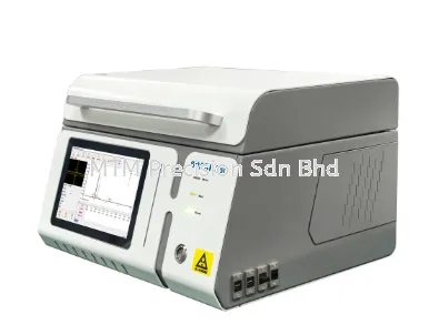
NavVis VLX 3 is a wearable dynamic 3D laser scanning system that captures three-dimensional measurements and panoramic imagery across complex indoor and outdoor environments. The operator wears the equipment and moves through the scanning area while the system records spatial information.
Unlike traditional terrestrial laser scanning workflows, which generally require multiple stationary scanner positions, a wearable mobile mapping system can document connected spaces continuously. This can improve field productivity for large buildings, factories, corridors and infrastructure projects, although actual efficiency depends on site conditions and required deliverables.
Key Features of NavVis VLX 3
1. Dual 32-Layer LiDAR Sensors
The system uses two 32-layer LiDAR scanners, each specified at up to 1,280,000 measurement points per second. The operational scanning range is up to 50 metres, depending on processing settings and site conditions. This configuration supports dense spatial capture across building interiors and complex industrial environments.
2. Four High-Resolution Panoramic Cameras
Four 20-megapixel cameras capture panoramic imagery to complement the 3D point cloud. These images provide visual context for equipment identification, facility documentation, construction reviews and remote site understanding.
3. SLAM-Based Mobile Mapping
Simultaneous Localization and Mapping (SLAM) technology estimates the scanner's trajectory while reconstructing its surroundings. This enables mobile data capture without requiring the operator to position a scanner at every measurement location. Careful route planning, sufficient environmental features and suitable control points remain important for data quality.
4. Survey Control and Geo-Registration
NavVis VLX 3 supports ground and wall control points. Survey professionals can use appropriately surveyed control coordinates to help register captured datasets to local or project coordinate systems. This is particularly important when integrating mobile scans with total station or GNSS survey work.
5. Live Scanning Feedback
A built-in 5.5-inch touchscreen provides live feedback during scanning. Operators can review coverage and SLAM status, helping identify potential capture issues before leaving the site.
6. Wearable Design and Hot-Swappable Batteries
The device weighs approximately 8.5 kg with two batteries installed. A set of two batteries provides approximately 1.5 hours of typical operation. Hot-swappable batteries support extended fieldwork when suitable charged batteries are available.
NavVis VLX 3 Technical Specifications
Specification | NavVis VLX 3 |
Scanner Type | Wearable mobile 3D laser scanning system |
LiDAR Sensors | 2 x 32-layer |
Laser Classification | Class 1 |
Operational Range | Up to 50 m |
Measurement Rate | Up to 1,280,000 points/second per sensor |
Point Cloud Accuracy | 5 mm local accuracy under specified test conditions |
Panoramic Cameras | 4 x 20 MP |
Display | 5.5-inch touchscreen, 1920 x 1080 |
Operating Time | Approximately 1.5 hours per battery set |
Storage | 1 TB portable SSD |
Weight | Approximately 8.5 kg with two batteries |
Control Points | Ground and wall |
Point Cloud Formats | E57, LAS, PTS, XYZ, PLY; additional formats may depend on software workflow |
Technical note: The manufacturer's 5 mm figure describes local point cloud accuracy in a dedicated test environment, not guaranteed absolute accuracy across every site. Actual performance depends on environment, scan planning, control, processing and verification. Specifications and software capabilities should be confirmed for the supplied configuration.
Applications of NavVis VLX 3 in Malaysia
Building Survey and As-Built Documentation
Surveyors and building consultants can use mobile scanning to capture existing building geometry for as-built surveys, renovation planning and architectural documentation. The resulting point clouds can serve as reference information for measurements, drawings and design coordination.
Construction and Engineering Projects
Construction teams may document structural layouts, completed works, corridors and complex interior spaces. Repeated scanning can support progress documentation and coordination, provided datasets are aligned and assessed against the project's accuracy requirements.
Industrial Plant and Factory Mapping
Industrial facilities often contain extensive pipework, machinery, access routes and mechanical services. Mobile 3D scanning for factories can support equipment layout documentation, retrofit planning, maintenance preparation and engineering coordination. Scanning must follow the site's safety and access procedures.
BIM and Scan-to-BIM Workflows
Point cloud data can be imported into compatible engineering and BIM software for modelling existing conditions. Scan-to-BIM is not an automatic guarantee of a finished BIM model: modelling effort, classification and quality assurance depend on the project's deliverables.
Digital Twin and Facility Management
Captured spatial data and panoramic imagery can help facility teams create a navigable visual record of a building or industrial site. When combined with suitable software, such as NavVis IVION, this information can support digital building documentation and remote collaboration.
Warehouses and Commercial Properties
Large warehouses, shopping complexes, office buildings and logistics facilities may benefit from efficient documentation of floor layouts, circulation areas, storage zones and building services. Project planning should consider moving objects, access restrictions and visibility limitations.
NavVis VLX 3 vs Traditional Terrestrial Laser Scanning
Wearable mobile scanning can reduce the number of stationary setups needed for continuous site documentation. However, traditional terrestrial laser scanners remain valuable when a project demands particular measurement characteristics, static observations or stringent verification procedures.
The best approach may combine mobile scanning for broad coverage with total station control and targeted static scanning for critical details. The correct method depends on required accuracy, environment, project scope and final deliverables.
Understanding Point Cloud Accuracy
NavVis specifies 5 mm local point cloud accuracy under defined testing conditions. This figure should not be interpreted as a universal 5 mm absolute coordinate tolerance or as a guarantee for every individual measurement.
For engineering or surveying projects, users should establish acceptance tolerances, suitable control point distribution, independent check measurements and a documented quality assurance process before data capture begins.
Typical 3D Scanning Workflow
Project planning: Define coverage, coordinate reference, deliverables and required accuracy.
Site preparation: Review access, safety, lighting and suitable control locations.
Mobile scanning: Walk a planned route while checking live coverage and tracking feedback.
Data processing: Process captured data using the appropriate NavVis software and licensed workflow.
Quality verification: Assess registration, coverage and accuracy against project requirements.
Delivery: Export supported point cloud and image deliverables for survey, BIM or facility management use.
Frequently Asked Questions
Is NavVis VLX 3 suitable for professional surveying?
Yes, it is designed for professional reality capture and surveying applications. Its suitability for a specific survey depends on project tolerances, control, site conditions and independent verification.
Can NavVis VLX 3 scan outdoors?
Yes. It supports indoor and outdoor scanning. Weather, environmental conditions, visibility and site geometry can affect practical scanning performance.
Does NavVis VLX 3 require GNSS during every scan?
No. It uses SLAM for mobile mapping. Surveyed control points and appropriate registration methods can be used where project or global coordinate alignment is required.
Can NavVis VLX 3 create BIM models automatically?
The system captures spatial data that can support BIM modelling. A finished BIM model typically requires additional processing, interpretation and modelling in suitable software.
Is training important?
Yes. Operator training helps teams understand scan route planning, control points, data processing, quality checks and safe field procedures.
Choosing NavVis VLX 3 for Your Project in Malaysia
Before selecting a professional wearable 3D laser scanner, consider the size and complexity of the scanning environment, expected accuracy, data formats, software licensing, processing requirements and technical training.
For projects in Kuala Lumpur, Selangor, Johor, Penang, Melaka, Negeri Sembilan, Perak, Pahang, Kedah, Kelantan, Terengganu, Perlis, Sabah and Sarawak, MTM Precision can be contacted to discuss the intended application and requested system configuration.
Contact MTM Precision Malaysia
Interested in NavVis VLX 3 for building surveys, industrial reality capture, engineering documentation or digital twin applications? Contact MTM Precision with your project scope, site size, required deliverables and expected accuracy so that suitable equipment and software requirements can be discussed.
MTM Precision Sdn Bhd
Showroom & Service Centre:
No 29-1 & 2, Jalan Bandar 18, Pusat Bandar Puchong, 47160 Puchong, Selangor, Malaysia.
Tel: 03-8080 7172
WhatsApp: +6016-660 7346
Email: mtmpre@yahoo.com
Website: www.mtmpre.com.my
Send your project details or site information via WhatsApp for a product and application enquiry.
Technical reference: NavVis VLX 3 official specifications and product documentation. Final configuration, software compatibility, accessories and service arrangements are subject to confirmation.
18 Oct 2026


