




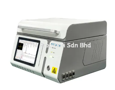


Cost-Effective Miniaturized CORS & Dual-Antenna Heading GNSS Receiver in Malaysia: The Toksurvey NET660i-H GNSS Receiver

Cost-Effective Miniaturized CORS & Dual-Antenna Heading GNSS Receiver in Malaysia: The Toksurvey NET660i-H GNSS Receiver
Across Malaysia's intelligent machine control, Beidou ground-based augmentation systems, precision navigation, and automated engineering sectors, system integrators require compact, high-precision reference receivers capable of dual-antenna heading determination
Core Engineering & System Characteristics
-
Embedded Linux Intelligent System: Driven by an ARM Cortex-A7 1.8GHz hardware platform and a built-in Linux operating system, delivering efficient onboard computation and operational stability
-
Multi-Constellation 1,408-Channel Tracking: Integrates 1,408 channels to provide an accurate onboard real-time navigation solution across GPS, GLONASS, BDS, Galileo, QZSS, and SBAS signals
-
Dual-Antenna Heading & Independent Differential Output: Supports dual-antenna directed positioning with dual-antenna independent differential output capabilities, making it an optimal choice for mechanical intelligent control systems
-
Cloud Service & Front-End Edge Calculation: Regularly reports device status—such as device location, network status, signal strength, and satellite reception status—while supporting cloud platform functions to remotely restart, reset, and upgrade the device
-
Versatile Protocol Compatibility: Supports Ntrip Client/Server/Caster, TCP Client/Server connections, FTP file transfers, HTTP/HTTPS protocols, and private network transfer functions with robust protection policies
Comprehensive Technical Specifications
GNSS Performance & Heading Accuracy
-
Channels & Signal Tracking: Features 1,408 channels supporting GPS (L1C/A, L2P/L2C, L5), GLONASS (L1, L2), BDS (B1I, B2I, B3I, B1C, B2b(PPP)), Galileo (E1, E5a, E5b, E6(PPP)), QZSS (L1, L2, L5), and SBAS (L1C/A)
-
Observation & Position Accuracy: Delivers a differential observation accuracy (RMS) of 10.0cm and a kinematic phase observation accuracy (RMS) of 10cm
-
RTK & Static Precision (RMS): Achieves high-precision RTK accuracy of ±(8mm + 1ppm) horizontally and ±(15mm + 1ppm) vertically, alongside static positioning accuracy of ±(2.5mm + 0.5ppm) horizontally and ±(5mm + 0.5ppm) vertically
-
Heading & Timing Accuracy (RMS): Delivers a heading accuracy of 0.2°/m and a timing accuracy of 20ns
-
Data Formats, Update Rates & Reliability: Supports RINEX and custom data formats, NMEA-0183 position data, and RTCM 3.X differential corrections across selectable update frequencies of 1Hz, 2Hz, 5Hz, 10Hz, and 20Hz
Interfaces, Communication & Data Storage
-
Serial & USB Interfaces: Equipped with a standard RS232 serial interface (supporting baud rates of 1,200, 2,400, 4,800, 9,600, 19,200, 38,400, 115,200, and 230,400 bps) alongside a USB port integrated on the 7-pin interface for direct computer data copying
-
Network & Physical Ports: Features a standard RJ45 10/100Mbps network adaptive port and full NetCom mobile network communication covering LTE FDD (B1/2/3/4/5/7/8/12/13/18/19/20/25/26/28), LTE TDD (B38/39/40/41), WCDMA (B1/2/4/5/6/8/19), and GSM (B2/3/5/8)
-
Onboard Storage: Features 32GB of internal storage supporting circular storage and multi-channel storage
Electrical, Physical & Environmental Resilience
-
Electrical Characteristics: Operates on a 9–24V DC voltage input (12V typical) with a low typical power dissipation of 2W
-
Enclosure & Dimensions: Housed in a durable magnesium alloy main body measuring 148.8mm × 105mm × 50.3mm and weighing 490g
-
Environmental Ratings: Built to IP68 dustproof and waterproof protection standards, operating and storing reliably across temperatures from -40°C to +85°C
Key Applications Across Malaysian Industries
-
Mechanical Intelligent Control Systems: Providing precise dual-antenna heading and independent differential positioning for heavy construction machinery, pavers, graders, and automated equipment
-
Beidou Ground-Based Augmentation & CORS Networks: Deploying compact, low-power reference nodes with edge-computing capabilities to minimize server bandwidth and processing loads
-
Marine, Unmanned & Precision Navigation: Delivering reliable 0.2°/m heading accuracy and multi-constellation RTK positioning in harsh tropical environments
Local Technical Support and Expertise in Malaysia
Located in Puchong, Selangor, MTM Precision provides expert system consultation, integration guidance, and dependable local technical support for Toksurvey (TOKNAV) geospatial and machine control solutions across Malaysia.
Contact MTM Precision
MTM Precision Sdn. Bhd.
Showroom & Service Centre
No. 29-1 & 29-2, Jalan Bandar 18,
Pusat Bandar Puchong,
47160 Puchong, Selangor, Malaysia
Email: mtmpre@yahoo.com
WhatsApp: +6016-660 7346
Office Tel: +603-80807172
14 Nov 2026


